These aerial photographs of the village were taken by Paul Wilkinson on Monday 2nd May 2005.
CLICK ON THE IMAGES BELOW TO SEE A LARGER VERSION.
|
 |
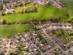
Sutton Park, with Holme Lane on the left side and Bridge Street at the top. |
| |
 |
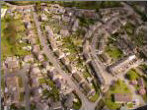
High Street, the Hall Estate, West Lane and up the Ellers |
| |
 |
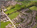
Croft Hill, Manor Way and The Acres. |
| |
 |
Hall Road Estate with West Lane curving from the bottom left corner and the Ellers from the right. |
| |
 |
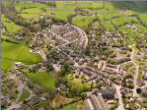
Sutton from the south, looking up the valley to Malsis. |
| |
 |
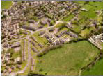
Holme Lane, Manse Way and the Sheilings Estate. Scene of the August 2004 flood. |
| |
 |
Thompson's Field, Holme Beck, Alvic Field, Rowan Garth, Meadow Lea and The Hawthorns. |
| |
 |
Hazel Grove Road and Ash Grove. |
| |
 |
Greenroyd Mill and Sutton Park. |
| |
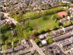 |
Sutton Park and St Thomas' Church. |
| |
 |
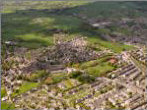
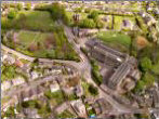
View of Sutton showing the Park, along the High Street and through to the Clough. |
| |
 |
Sutton Fields, Lyndhurst Woods and Hayfield Mills, looking up the valley past the Dog and Gun to Cowling in the distance. |
| |


